
Capture Fisheries Resources of India: India has the distinction of being one of the third largest producers of fish in the world and ranks second in terms of total inland fish production after China and Bangladesh (FAO, 2010). All in all, this sector has been recognized as a powerful income and employment generator since it stimulates the growth of a number of allied industries and also is source of cheap animal protein. It is an instrument of livelihood for a large section of economically backward population of the country.
Of the two sectors viz. marine and inland in the Indian fisheries, the inland sector remains a sector of much promise. Unlike agriculture, because of expansion of culture based fisheries enterprise, the contribution of inland fisheries sector to grow domestic product has been increasing at a significant rate. This sector is a complex enterprise which operates under the intensified network of natural resources, other enterprises with fisheries and other socio-political variables. The inland fishery resources of the country comprises of the rivers and canals, reservoirs, tanks and ponds, estuaries, brackish water lakes, backwaters, floodplain lakes (oxbow lakes) etc. while the marine water bodies are mainly used for capture fisheries resources, the inland water bodies are widely used for culture and capture fisheries. Inland capture fisheries of India has an important place; it contributes to about 30% of the total fish production. The large network of inland water masses provides great potential for economic capture fishery. ‘Capture Fisheries Resources of India’
Capture Fisheries Resources of India
Capture fisheries resources are a vital part of India’s fisheries sector, contributing about 30% of the total fish production. India’s rich aquatic resources can be broadly divided into two categories:
Inland fisheries Resources of India
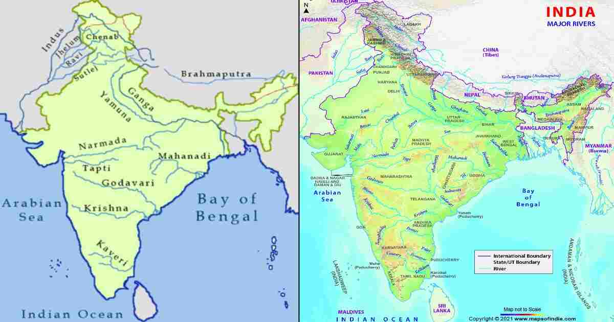
India has a total water surface area of 3,14,400 sq km with water resources in the form of numerous rivers, streams, wetlands, lakes,etc., and receives an average annual rainfall of 1,100 mm. The country as a whole has a river length (including canals) of 1,95,210 km, reservoirs of 29.07 lakh ha, tanks and ponds of 24.14 lakh ha, flood plain lakes and derelict water bodies of 7.98 lakh ha, and brackish water areas of 12.40 lakh ha. A major part of the river stretches and canals are concentrated in the states of Uttar Pradesh, Jammu and Kashmir, Madhya Pradesh, Maharashtra, Andhra Pradesh, Karnataka and Tamil Nadu. Much of the reservoir areas falls in the states of Tamil Nadu, Karnataka, Maharashtra, Orissa, Gujarat, Andhra Pradesh,Madhya Pradesh, Uttar Pradesh and Rajasthan. Tanks and ponds are concentrated in the states of Andhra Pradesh,Karnataka, West Bengal, Arunachal Pradesh, Rajasthan and Orissa. A large part of the area under flood plain lakes and derelict water bodies is found in Kerala, Orissa, Uttar Pradesh and Assam. Brackish water areas are concentrated in the maritime states of Orissa, Kerala, West Bengal, Gujarat,Goa, Andhra Pradesh and Tamil Nadu and in the Union territory of Andman and Nicobar Islands. Total area under water bodies (excluding rivers and canals) is found to be maximum in Orissa, followed by Andhra Pradesh, Karnataka, TamilNadu, West Bengal, Kerala, Uttar Pradesh, Gujarat, Maharashtra, Rajasthan, Madhya Pradesh, etc. in that order. There are several wetlands being shared with neighbouring countries too as in case of Ladakh and Sunderbans. The major river basins of the country are the Ganges,Brahmaputra, Narmada, Tapti, Godavari, Krishna and Cauvery. ‘Capture Fisheries Resources of India’
Open water fishery resources of india: ‘Capture Fisheries Resources of India’
| Resources | Resource potential | Mode of management |
| Rivers (km) | 29000 | Capture fisheries |
| Mangroves (ha) | 356000 | Subsistence |
| Estuaries(ha) | 300000 | Capture fisheries |
| Estuarine wetlands / bheries (ha) | 39600 | Aquaculture |
| Backwaters/lagoons (ha) | 190500 | Capture fisheries |
| Large & Medium reservoirs (ha) | 1667809 | Enhancement (stock and species) |
| Small reservoirs (ha) | 1485557 | Capture based fisheries |
| Flood plain wetlands (ha) | 202213 | Capture based fisheries |
| Upland lakes (ha) | 720000 | Not known |
The above table shows that large and medium reservoirs constitute the most important resource base for inland fisheries, followed by small reservoirs, upland lakes, flood plain wetlands,mangroves, estuaries and backwaters/lagoons, in that order. ‘Capture Fisheries Resources of India’
2.1.3 Riverine fishery resources
The following table provides the details of major rivers of India, their length and distribution over states. ‘Capture Fisheries Resources of India’
Length of major rivers of India
| S.No. | River | Total length (km) | Distribution over states | Length (km) |
| 1. | Ganga | 2525 | (a) Uttar Pradesh | 1450 |
| (b) Bihar | 445 | |||
| (c) West Bengal | 520 | |||
| (d) Boundary of Bihar and U.P | 110 | |||
| 2. | Brahmaputra | 916 | (a) Arunachal Pradesh | 218 |
| (b) Assam | 698 | |||
| 3. | Indus | 1114 | Jammu & Kashmir | 1114 |
| 4. | Brahmani | 799 | (a) Orissa | 541 |
| (b) Bihar | 258 | |||
| 5. | Krishna | 1401 | (a) Maharashtra | 640 |
| (b) Andhra Pradesh | 386 | |||
| (c) Karnataka | 375 | |||
| 6. | Mahanadi | 851 | (a) Madhya Pradesh | 357 |
| (b) Orissa | 494 | |||
| 7. | Sabarmathi | 371 | (c) Rajasthan | 48 |
| (d) Gujarat | 323 | |||
| 8. | Narmadha | 1312 | (a) Madhya Pradesh | 1079 |
| (b) Gujarat | 159 | |||
| (c) Boundary of M.P and Gujarat | 39 | |||
| (d) Boundary of M.P and Maharashtra | 35 | |||
| 9. | Mahi | 583 | (a) Madhya Pradesh | 167 |
| (b) Rajasthan | 174 | |||
| (c) Gujarat | 242 | |||
| 10. | Tapti | 724 | (a) Madhya Pradesh | 228 |
| (b) Maharashtra | 228 | |||
| (c) Gujarat | 214 | |||
| (d ) Boundary of M.P and Maharashtra | 54 | |||
| 11. | Godavari | 1465 | (a ) Andhra Pradesh | 771 |
| (b ) Maharashtra | 694 | |||
| 12. | Pennar | 597 | (a) Karnataka | 61 |
| (b) Andhra Pradesh | 536 | |||
| 13. | Cauveri | 800 | (a ) Karnataka | 320 |
| (b) Tamilnadu | 416 | |||
| (c) Boundary of Karnataka and Tamilnadu | 64 | |||
| 14. | Subarnarekha | 395 | (a) Jharkhand * | 269 |
| (b) West Bengal | 64 | |||
| (c ) Orissa | 62 |
*www.dowrorissa.gov.in (earlier, in place of Jharkhand, Bihar was mentioned.
Source: Department of Animal Husbandry and Dairying, 2001 Much of the Ganga flows through Uttar Pradesh, Bahmaputra through Assam, Indus through Jammu and Kashmir, Brahmini through Orissa, Krishna through Maharastra, Mahanadi through Orissa, Sabarmati through Gujarat, Narmada through Madhya Pradesh, Mahi through Gujarat, Tapti evenly through Madhya Pradesh, Maharashtra and Gujarat, Godavari through Andhra Pradesh and Maharashtra, Pennar through Andhra Pradesh, Cauveri through Tamil Nadu and Karnataka and Subanarekha predominantly through Jharkhand. ‘Capture Fisheries Resources of India’
Marine Capture Fisheries
The capture marine fishery resource of India comprises of a long coastline (8118 kms.) and Exclusive Economic Zone (EEZ) (2.025 sq. kms). Marine capture fisheries play a vital role in India’s economy, providing employment and income to nearly two million people. The marine fishing fleet is estimated to be 280491 nos., consisting of traditional crafts (181284 nos.), motorized traditional craft (44578 nos.) and mechanized boats (53684 nos.). In the total marine fish production, the share of traditional, motorized and mechanized sector is estimated at 9%, 26% and 65% respectively. ‘Capture Fisheries Resources of India’
Coastal resources up to 100 m depth are subject to intensive fishing pressure and is exploited at levels close to or exceeding optimum sustainable limit. While the inshore waters have been almost exploited to the Maximum Sustainable Yield (MSY) levels, the contribution from the deep sea has been insignificant, hitherto directed at shrimps only. Having almost reached a plateau in production from the coastal waters, the scope for increasing fish production from marine sources now lies in the deep sea. Of the many options to harness deep-sea fishery resources, diversification of the existing deep sea fishing fleet and introduction of resource specific vessels for long lining, purse seining and squid jigging is catching more attention.